
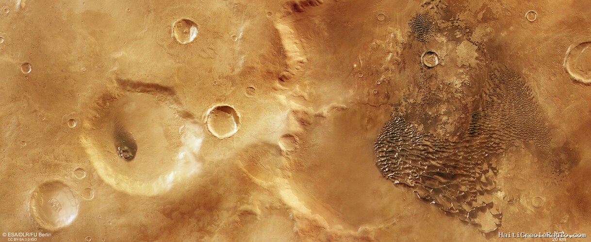
The European Space Agency’s Mars Express has spotted a swathe of metallic-looking waves filling Mars’s large Kaiser Crater – an ancient and otherworldly dune field sculpted by wind.
This month’s snapshot of Mars, taken by the High Resolution Stereo Camera (HRSC) aboard ESA’s Mars orbiter, captures one of the oldest parts of the Red Planet: Noachis Terra. Situated in Mars’s ancient southern highlands, Noachis Terra has been heavily bombarded with rocks from space over the past four billion years – and the scars from these collisions are clear to see.
This image is packed with impact craters. The right half of the image is dominated by part of the floor of the giant Kaiser Crater, a large basin that measures about 180 km across and a couple of kilometres deep. The prominent ridge running down the middle of the image marks part of the crater’s southern rim.
To the left side is a wide scattering of smaller craters, some with crisp edges and others that have been gradually worn away over time. The difference in elevation between the left and right sides of this image – a result of Kaiser Crater’s formation – is marked and fascinating, and best seen in the associated topographic map below.
A number of notable craters also lie nearby but out of frame (see context map below), including Greeley, Le Verrier, and Neukum Craters. All of these craters have been the focus of previous Mars Express releases, and the last is named after Gerhard Neukum: one of the planetary scientists that founded the Mars Express mission itself and led the development of the spacecraft’s HRSC.
Sandy waves shaped by water and wind
Much of the floor of Kaiser Crater is covered by distinctive, dark, almost shiny waves that look almost as if they’re carved out of metal. These ridges are sand dunes that have been moulded by martian winds – they can tower more than 100 m above the surrounding surface. Some are more solitary and isolated, while others merge to form a continuous dune field that extends for several kilometres. Their shiny, slightly metallic appearance is caused by bright frost deposits on their south-facing slopes.
This dune field comprises a mix of ‘transverse’ and ‘barchan’ dunes. Barchan dunes are sickle-shaped; they are the most common type of dune found on Mars and also prevalent in Earth’s deserts (such as Africa’s Sahara and Namib deserts). Also seen on our planet, transverse dunes are instead more elongated and parallel in their distribution, and can evolve as barchans accumulate more and more sand. Both types of dune are formed by sand building up and being swept about by winds blowing from the same direction.
The winds in this part of Mars blow predominantly from the west (top), pushing and moving sand around to form these distinctive wave crests. The sand itself is fine and basaltic in nature – meaning that it’s rich in minerals such as pyroxene and olivine, which are formed by volcanoes – and is constantly in motion, causing these dynamic landforms to slowly change and evolve over time.
There are also signs of water-related activity here. Martian winds have stripped away the upper layers of the planet’s surface in places, revealing light-toned clay rock that likely formed in the presence of water. There are also little gullies and narrow channels lining the steeper walls of some of the craters here – while these were likely formed by dry landslides slipping down unstable slopes, some of the older gullies may have formed as ice reserves melted, or buried groundwater reservoirs caused the ground above to shift.
Decades of Mars exploration
This image comes courtesy of the HRSC camera, one of eight instruments aboard Mars Express.
Mars Express has been capturing and exploring Mars’s many landscapes since it launched in 2003. The orbiter has mapped the planet’s surface at unprecedented resolution, in colour, and in three dimensions for over two decades now, returning insights that have drastically changed our understanding of our planetary neighbour (read more about Mars Express and its findings here).
The Mars Express HRSC was developed and is operated by the German Aerospace Center (Deutsches Zentrum für Luft- und Raumfahrt; DLR). The systematic processing of the camera data took place at the DLR Institute of Space Research in Berlin-Adlershof. The working group of Planetary Science and Remote Sensing at Freie Universität Berlin used the data to create the image products shown here.



Commentaires (0)
Laisser un commentaire
Aucun commentaire. Soyez le premier !