
The European Space Agency's two-satellite HydroGNSS Scout mission has completed commissioning and is now in full scientific operations.
Following extensive testing and validation of the satellites, instruments and ground segment, HydroGNSS data are now freely available to users worldwide, opening new opportunities to advance our understanding of water availability and the impacts of climate change on Earth's water cycle.
Launched in November 2025, the HydroGNSS satellites use Global Navigation Satellite System Reflectometry (GNSS-R) to observe key hydrological variables from space.
The mission captures L-band signals transmitted by navigation satellites such as GPS and Galileo after they have reflected off Earth's surface. By comparing these reflected signals with those received directly from the navigation satellites, HydroGNSS can derive information on soil moisture, inundation and wetlands, freeze–thaw dynamics, and above-ground biomass, helping scientists better understand the processes shaping our changing planet.


Access the video
Over the last eight months, mission teams have carefully evaluated the satellites' performance, verified the instruments, and calibrated the data products to ensure they meet mission requirements. The successful completion of commissioning confirms that the satellites and ground segment are performing as expected and are ready for routine operations.
As ESA's first Scout mission, developed under the Earth Observation FutureEO programme, HydroGNSS exemplifies the New Space approach. The Scout programme enables innovative mission concepts and emerging satellite technologies to be developed and demonstrated rapidly and cost-effectively.
Using this approach, the mission was developed for ESA by Surrey Satellite Technology Ltd (SSTL), which designed, built and now operates the two satellites.
Building on GNSS-R technology previously demonstrated on TechDemoSat-1 and the CYGNSS mission, SSTL developed an advanced instrument capable of exploiting multiple GNSS constellations, frequencies and polarisations to deliver enhanced environmental observations.
Working with an international team of scientific partners, SSTL processes these measurements into data products that provide new information on soil moisture, flooding and wetlands, seasonal freeze–thaw conditions, and vegetation, supporting research into the global water cycle and its response to climate change.
ESA’s Scout Project Manager, Jean-Pascal Lejault, said, “This is a real milestone, not only for the HydroGNSS mission, but also for the Scout component of ESA’s Earth Observation FutureEO programme.
“Reaching full scientific operations demonstrates the success of this innovative approach to developing agile, low-cost Earth observation missions. We would like to thank everyone involved in making this achievement possible – from the engineering and science teams to our industrial and institutional partners. Their expertise, dedication and commitment have brought HydroGNSS from concept to a fully operational mission in orbit, ready to deliver valuable new insights into Earth's water cycle.”


Open Image
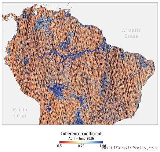
The images, prepared by IEEC and ICE-CSIC, presented side-by-side above demonstrate HydroGNSS’ ability to detect surface water at high resolution, including beneath vegetation canopies.
The left image shows measurements from HydroGNSS’ coherent channel, which uses the behaviour of reflected GNSS signals to identify water surfaces. The data are collected along satellite tracks at 300 m resolution, with observations from both satellites combined over time to build a more complete picture.
The right image shows a global flood map generated using C-band radar data from Sentinel-1 over the same region. Unlike GNSS-R, radar signals can have difficulty detecting water beneath dense vegetation. HydroGNSS therefore provides a new way to observe wetlands hidden below forest canopies, helping improve estimates of these important ecosystems and their role in the global carbon cycle.
The HydroGNSS Project Manager at SSTL, Peter Garner, said, “After so much hard work by a dedicated team, it is very rewarding to reach this major milestone. I particularly like the circular nature of the overall process at play, with roughly half the reflected signals being collected by this SSTL built pair of satellites being generated by the Galileo navigation satellites’ payloads that were also built and delivered by SSTL, the signals are coming home.”
Users can find more information about HydroGNSS data products and register for access through the SSTL HydroGNSS website.


Commentaires (0)
Laisser un commentaire
Aucun commentaire. Soyez le premier !