Satellite measurements are showing a sharp surge in sea-surface temperatures across the tropical Pacific in recent months – the clearest early signal that El Niño is back.
This powerful climate pattern, and its counterpart La Niña, can supercharge weather worldwide, amplifying extremes from heatwaves and droughts to torrential rainfall, floods and disrupted winter storm tracks, all on top of the effects of the already warming climate driven by human activity.
The coupled ocean–atmosphere system of El Niño and La Niña, together known as the El Niño Southern Oscillation, are drivers of significant variations in global temperature and precipitation.
El Niño occurs every few years when the trade winds weaken allowing warm surface waters in the western Pacific Ocean to shift eastwards.
This change in ocean temperature reshapes wind patterns and atmospheric circulation, triggering a cascade of impacts that can influence weather across the globe.
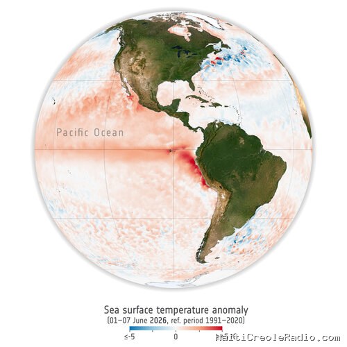
An El Niño event often begins subtly, with unusually warm surface waters developing across the tropical Pacific Ocean – conditions that are being observed now.
The animation below highlights early signs of this developing event by showing sea-surface temperature anomalies from 1–7 June 2026 compared with the 1991–2020 average for the same period.


Access the video
ESA’s Craig Donlon explained, “We use anomalies – the difference between current conditions and the long-term average because El Niño often begins as a subtle shift from what is considered normal, and these early changes are easier to see against a reference pattern. Although the temperature differences may appear small, the ocean stores and exchanges enormous amounts of heat, so even slight warming can indicate very large changes in the energy flowing between the ocean and the atmosphere.”
That extra heat can strengthen rising motion and rainfall over the tropical Pacific and alter atmospheric circulation far beyond the Tropics. In some cases, these changes can generate large-scale atmospheric waves that propagate towards higher latitudes and upward into the stratosphere. This can, under the right conditions, increase the likelihood of a weaker polar vortex or a disrupted European winter circulation pattern.
If such a disruption occurs, its effects can sometimes work downwards into the lower atmosphere over the following weeks, influencing the jet stream and the likelihood of persistent weather patterns over parts of the North Atlantic and Europe. This does not mean El Niño directly causes cold winters in Europe, but it can tilt the odds of certain winter patterns, especially when combined with other factors such as the quasi-biennial oscillation, which also affects how easily the polar vortex is disturbed.
Scientists monitor these evolving conditions using satellites, weather balloons and computer models. No single observation can determine how winter will unfold, but combining these sources helps forecasters assess whether the atmosphere is becoming more prone to large-scale circulation changes.
El Niño is one phase of the El Niño–Southern Oscillation. Conditions sometimes shift toward La Niña afterwards, but not always, and the timing and strength of that transition vary from event to event.

Access the video
Measurements of sea-surface temperature from satellite missions such as Copernicus Sentinel-3 are key to keeping an eye on changes in the temperature of the sea surface. Its sea and land surface temperature radiometer measures global sea-surface temperature, and land-surface temperature for that matter, every day to an accuracy of better than 0.3 K, providing critical data for tracking evolving ocean conditions.
As seawater warms, it also expands, contributing to changes in sea level. Here again, measurements from Copernicus Sentinel-3, its synthetic aperture radar altimeter, provide key information.
The third Copernicus Sentinel-3 satellite, Sentinel-3C, is set for launch this autumn to ensure continuity of these kind of data.
The influence of this year’s El Niño on Pacific sea-level anomalies is expected to become more apparent in the coming months using satellite altimetry.
The Copernicus Sentinel-6 mission (the reference mission for satellite altimetry) complemented by two altimeters carried by the current Sentinel-3 satellites provide Europe with unique information on sea level and sea level anomalies.
Satellite measurements from the infrared atmospheric sounding interferometer instrument on the MetOp weather satellites and the recently launched MetOp-Second-Generation-A1 satellite are useful to look at the quasi-biennial oscillation.
Ultimately, scientists emphasise that the strength of modern climate monitoring lies in combining satellite observations with models that integrate multiple lines of evidence, allowing a more complete understanding of the evolving El Niño–Southern Oscillation system.


Commentaires (0)
Laisser un commentaire
Aucun commentaire. Soyez le premier !