The European Space Agency’s Mars Express has captured part of Mars’s Mamers Valles: a fascinating valley system speckled with brief, tornado-like whirlwinds known as dust devils.
Dust devils form as parts of Mars warm in the Sun, causing the air just above the surface to swirl upwards and carry dust with it as it goes. Mars’s dust devils are similar to those we see in dry, dusty landscapes on Earth, but far larger; they tower up to eight kilometres high, rove about for kilometres at a time, and reach top speeds of 45 metres per second. They play a key role in moving dust across the planet.
Mars Express is uniquely equipped to spot these mini whirlwinds. To form a single image using its High Resolution Stereo Camera – the instrument responsible for these new snapshots – the spacecraft combines sequential views from up to nine separate camera channels (which look at Mars in a different colour, from a different direction, or a mix of the two). If nothing changes on the martian surface while these are being taken, the multiple perspectives align – but if something is moving about, it stands out clearly from its surroundings (read more on this process).
In this new set of images, Mars Express captures not one but dozens of active dust devils. Click on the image below to see more than 30 circled, each visible as a small yellow dot with a pinkish trailing ‘shadow’.
The alignment and combination of Mars Express’s various camera channels also allows us to figure out the direction and speed of Mars’s dust devils. This is something that scientists have done using data from both Mars Express and ESA’s ExoMars Trace Gas Orbiter, revealing how more than 1000 of these tornado-like storms move – and tracing how winds sweep around the planet (read more).
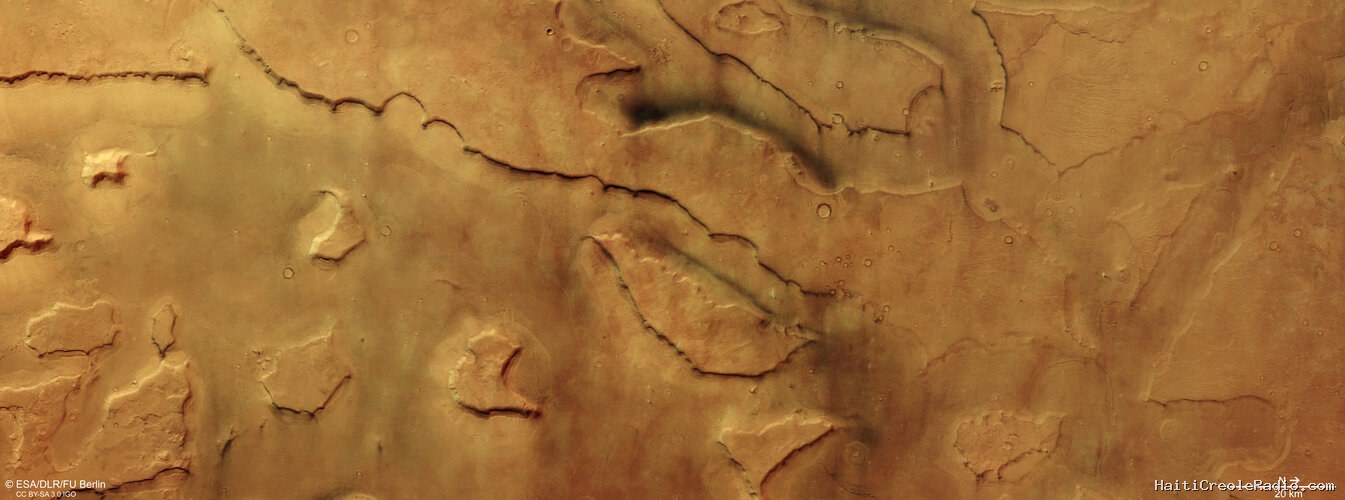
Canyons and channels
Mamers Valles is a vast, broken-up, labyrinthine system of canyons and valleys etched into Mars’s surface. The feature was named in 1976 based on the ancient Oscan language of pre-Roman Italy, with ‘Mamers’ meaning ‘Mars’ and ‘Valles’ meaning ‘Valley’.
These channels stretch out for around 1000 km, crossing from Mars's ancient southern highlands into the planet's northern lowlands, and in places measure up to 25 km wide and 1.2 km deep (as shown most clearly in the associated topographical map below).
Surrounding these channels are various fascinating features: steep, flat hills known as mesas, sheer cliffs, and debris-covered glaciers. These glaciers contain water ice buried beneath a cover of rock and dust, and can be seen building up at the base of the steep slopes pictured here. All of these landforms come together to form fragmented or ‘fretted' terrain.
Patches of dark material can also be seen lining a couple of the valleys – likely volcanic sands that either formed in place or have been swept in by winds.
Many of the features seen here are signs of past activity related to water, lava, or ice, all of which once flowed across this terrain and carved out telltale marks as they did so.
For instance, the valley floors are marked by long ridges and textures that formed as debris-covered glaciers slid down both sides of the valley, ultimately meeting in the middle. These same icy signatures line the steep cliffs and hillsides, too. Although water ice isn't stable on Mars's surface today, it has managed to survive here because it was covered by rocky material, which has stopped it from escaping to the martian atmosphere.
Mamers Valles
Mars Express has visited this region of Mars before, imaging the areas surrounding both Mamers Valles (2008) and the neighbouring Deuteronilus Mensae (2019).
The region dates back to around 3.8 billion years ago, to a part of martian history known as the late Noachian period. This era is a significant one, as it marks when Mars began to transition from a warmer, wetter, more geologically active world to the cold, arid one we see today.
Decades of Mars exploration
This image comes courtesy of the HRSC camera, one of eight instruments aboard Mars Express. Mars Express has been capturing and exploring Mars’s many landscapes since it launched in 2003. The orbiter has mapped the planet’s surface at unprecedented resolution, in colour, and in three dimensions for over two decades now, returning insights that have drastically changed our understanding of our planetary neighbour (read more about Mars Express and its findings here).
The Mars Express HRSC was developed and is operated by the German Aerospace Center (Deutsches Zentrum für Luft- und Raumfahrt; DLR). The systematic processing of the camera data took place at the DLR Institute of Space Research in Berlin-Adlershof. The working group of Planetary Science and Remote Sensing at Freie Universität Berlin used the data to create the image products shown here.


Commentaires (0)
Laisser un commentaire
Aucun commentaire. Soyez le premier !