
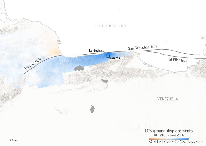
More than one month on from the catastrophic twin earthquakes in northern Venezuela on 24 June 2026, satellite data show the ground displacement was greater than first estimated.
The map below shows the ground displacement captured by radar instruments carried by the Copernicus Sentinel-1 satellites, which passed over the northern coast of Venezuela on 18 June before the earthquakes occurred, then afterwards on 24-25 June. The measurements taken on the 24 and 25 June were compared with the previous measurements from 18 June, to ascertain differences in ground level following the earthquakes. An upwards displacement of 65 cm around Caracas was measured by the mission's radar instruments.
Measuring ground movement with radio waves
The data for the map are created using a technique called interferometry. This uses measurements taken before and after the displacement event, captured by missions carrying advanced radar instruments, such as the C-band synthetic aperture radar (SAR) instrument on board the Sentinel-1 satellites.
As a satellite passes overhead, it sends out radar pulses (radio waves travelling at the speed of light). These are directed towards the ground at a diagonal angle (rather than vertically), hitting the ground to the side of the satellite’s orbital path over Earth. The radar wave is reflected off the ground and the satellite measures the length of the returning wave. This gives very accurate information on ground level, to within a millimetre, although ground covered by vegetation will give less accurate readings.
Because the satellite’s radar travels diagonally in a straight line, it can only measure displacement in the satellite’s ‘line of sight’ – in other words, it is not a vertical measurement, but a measurement of displacement in relation to the satellite, as detected by the satellite’s oblique angle. Information on whether the ground has moved vertically, horizontally or both is not included in the image shown above.
The measurements taken on 24 and 25 June, compared with measurements on 18 June, show an upwards displacement of 65 cm around Caracas, La Guaira and Caraballeda, with some downwards displacement north of the Boconó fault line. However, since the satellite’s line-of-sight data were not compared with any ground measurements after the event, the map should be viewed as guidance rather than a validated map. The preliminary data from Sentinel-1 released five days after the earthquakes indicated ground displacement of the order of 30 cm.
ESA’s Mission Manager for Sentinel-1, Nuno Miranda, noted: “Earth observation satellites equipped with radar provide insightful and rapid information in the wake of natural disasters – and the radar data supplied by Sentinel-1 is an excellent example of this. While there are some limitations of these measurements due to vegetation or other surface textures, this can be corrected through repeated measurements as the satellite orbits in both a descending and an ascending orbit, as is the case for Senintel-1, which is in a polar orbit.”
Activating Copernicus services
The Copernicus Emergency Mapping Service (EMS) was activated (activation number EMSR884) on 25 June, some five hours after the earthquakes occurred. The second of the two shocks, measuring 7.5-magnitude, had a devastating effect on lives and infrastructure in urban centres. Copernicus EMS Rapid Mapping was requested to provide damage assessment emergency mapping.
With the epicentre west of Caracas, severe damage was reported in the areas of Greater Caracas and La Guaira, approximately 30 km north of the capital. The Copernicus EMS report on the disaster found that more than 3000 buildings in the area were damaged and more than 2.7 million people were potentially in the affected areas. The coastal town of Caraballeda, next to La Guaira, is one of the most seriously damaged areas, according to Copernicus situational reporting.
Fault lines studied from space
The earthquakes in Venezuela on 24 June were caused by a shallow slip-strike movement in the tectonic plates that push against each other under the sea off the coast of Venezuela. The Caribbean tectonic plate pushes eastwards against the South American tectonic plate at a rate of about 15 mm per year, along the San Sebastián fault line.
Machel Higgins, a geophysicist at Florida International University, said, “The co-seismic Sentinel-1 interferograms clearly indicate that most of the rupture from these two earthquakes occurred offshore. This observation aligns well with our recent study of interseismic deformation, which used eight years of continuous Sentinel-1 radar data to track long-term strain accumulation at this plate boundary. That data informed our models, which revealed that the western section of the offshore San Sebastián fault is fully locked. The last large magnitude earthquake on this fault was a 7.6-magnitude in 1900. Given that the fault accommodates about 15 mm a year of relative motion between the Caribbean plate and the South American plate, we expected the fault to generate magnitude 7.5 earthquakes. By directly linking long-term satellite monitoring with actual earthquake behaviour, this work underscores the invaluable role space-based geodetic observations play in mapping critical seismic hazards.”



Commentaires (0)
Laisser un commentaire
Aucun commentaire. Soyez le premier !